Off The Beaten Path

By 8:30 a.m. we had crossed the reef line and watched with regret as the beautiful beach at Tulum faded behind us. The weather forecast was for another perfect day with the exception of predicted light wind. Our destination was only 35 miles south of our current location, but it would be a motorsail all the way. As with our arrival, we were holding our distance from the reef line to approximately one mile, and as a result a favorable current of 1.5 knots helped move us along. Since we were under power and charging batteries from the engine we used the time to run the watermaker and fill our tanks. The system is 12 volts and takes around 25 amps, so the assist from the alternator was welcomed.

At around 10:30 a.m. I did my usual visual inspection of the bilge and engine compartment with no surprises. The autopilot was steering us effortlessly to our next waypoint and all was good with the world. It is days like this that make all our hard work and efforts to prepare for this trip totally worthwhile.

Around noon we were sitting in the cockpit contemplating lunch when the familiar sound of the fishing reel set us into action. We had done well on this part of the coast so we knew what to do. Susan eased the throttle back to idle and I grabbed the reel. Within a few minutes we had landed another blue fin tuna. We were beginning to wonder if any other species roamed these waters but we were not complaining. Once again, fresh tuna would grace the captain’s table for dinner. And fresh tuna salad is always one of Susan’s favorites for lunch.

A dramatic reminder
The break in the reef at Bahia Ascension is very wide and there are few or no breakers to show us the edges at the entrance. As we approached the bay we first noticed something large and white some distance off to our starboard. As we moved further along the reef we both determined what it was at about the same time. The shining white hull of a pretty good-size sailboat was lying on its side on the top of the reef — a dramatic reminder that a mistake along this coastline could be serious and disastrous.

We wondered aloud how the wreck might have happened. Did the boat lose steering and drift up on the reef? Did the crew make a fatal mistake in navigation? Was a storm responsible? The hull seemed pretty much intact so it must have only been there a short time. Anyone who has spent any time cruising will understand the feeling you get in the pit of your stomach anytime you encounter such a sight.

Now it was our turn to cross that same reef without mishap. We had been provided a set of waypoints by a friend in Isla Mujeras that had been in and out of here only a couple of weeks before. Even with first-hand waypoints we are always cautious and a little apprehensive. We had plotted them on our paper charts, and on the electronic charts on the computer as well as entering them into the GPS as part or our route. All seemed in agreement that we would enter with a good margin of safety.

The first waypoint was outside the reef line and put us in a good position to maneuver to the second waypoint inside the reef line. Even with good coordinates we still always maintain a watch on the foredeck and, when entering a pass, will even climb the rigging using our mast steps to get us high enough to get a good visual on the depths and the periphery of the reef pass. Our third waypoint put us well inside the bay. Our anchorage was a good five miles once we had crossed over the reef line. From our third waypoint the rest was all eyeball. We knew from information we had gathered and from our guidebook of the area that there was a shallow bar that extended almost a quarter-mile off the north end of Culebra Cay, where we planned to anchor. So from our third waypoint we headed directly for the north end of the cay, then maintained the quarter-mile distance once we were close in. We saw no less than 12 feet of water all the way to our anchoring spot on the west side of the cay. There we would have good protection from the swells that worked in from the sea as well as the prevailing easterly winds. As usual, things were going too easily.

An uninvited guest
It became apparent from the thick grass on the bottom and a few attempts to set the anchor that our CQR was not going to grab. Both our primary and secondary anchors are CQR so that meant switching one out for our Danforth. This takes a little time since we always make sure the anchor shackles are wired closed for safety. But by 3:30 p.m. local time we were anchored, and began to open the boat up and settle in for a few days of rest and relaxation. Almost as soon as we had the cockpit stowed and went below we heard a scratching sound on deck. We both noticed it and went topside to inspect. We both know that new sounds unfamiliar to us sometimes mean problems.

As we came out on deck we found a pigeon had landed on deck and was walking around as if disoriented or not well. This has happened in the past when a stray bird came in contact with our wind generator. This one did not have any visible injuries. But we also knew what kind of a mess birds make on the deck and canvas. So we made an attempt to coax her off and convince her to fly away. She would have none of it and ran around the deck staying just out of our reach. The end of any passage, no matter how short, is time to just relax, so we decided to leave the bird be for now and perhaps she would just leave later.
We went below and started planning dinner for the evening, and doing a few boat chores. Not giving the bird another thought we finally sat down at the table for dinner a couple of hours later, and suddenly noticed the bird standing outside the companionway screen watching us eat.

Since Susan is an old softy she insisted on giving her food and water. I warned her that if we did, the bird would move aboard, and reminded her of what the decks would look like the next morning — but she insisted. The bird stayed with us for another day and a half, then just flew away. No thank you or anything, just little deposits everywhere.

Questioning the guidebook
For the next couple of days we just relaxed and enjoyed our quiet and peaceful anchorage. The VHF radio is always on and we had picked up the conversations of two boats that were heading into the bay. They were happy to hear that we were already inside, and we gave them our waypoints in. We had also picked up a boat on the Northwest Caribbean Net that morning that was heading in, and we shared our waypoints. The anchorage was soon to get crowded. By that evening we were sharing the anchorage with two trawlers and a large motorsailer with friendly crews aboard. We found that we were all heading in the same general direction, for Belize. The folks on the motorsailer had just made a five-day passage from the United States.

The settlement at Punta Allen was about three miles due north of us in the bay. Our guidebook suggested it was unimpressive and not worth a visit. In addition, there was a naval base there and a visit could result in a hassle from officials.

One morning we happened to pick up a conversation on the VHF from a couple of boats that sounded close by. So we jumped in and introduced ourselves. We were surprised when they told us they were anchored near the settlement, and it was really a great little place and we should visit before we left. Within the hour we’d hauled up anchor and moved the three miles to the anchorage behind Punta Gorda.

After we splashed the dinghy we stopped to chat with one of the boats we had communicated with earlier. They gave us the scoop about the town and where everything could be found, including the new town-built dinghy dock, the local tiendas — or grocery stores — and the all-important Internet cafe.

We found the town delightful, and the people friendly and helpful. We learned they are trying hard to attract tourists since this area is famous for its fishing, and diving and snorkeling on the reefs. As evidence of their sincere intentions, it appeared they had converted every other house on every street into a restaurant.

We stayed another two days just to enjoy the settlement. The navy presence was never a problem, and they were always friendly and polite when we met them on the street. But we knew it was time to continue pushing south.
Be Flexible

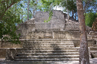
For years I have dreamed about visiting Mayan ruins — ever since I dug up that first tooth in my mother’s flowerbed at the age of 10. I thought I had found some wonderful artifact, but it was, in fact, an old cow’s tooth. Our property used to be pastureland. Oh well. I was still interested in archaeology and decided one day I would immerse myself in history. Tulum, about 80 miles south of Cancun on the Yucatan peninsula and until the 1960s accessible only by sea, seemed like the place to start. Chuck and I pored over the charts of the Mexican coast to decide our next stop after Punta Maroma. The number of good and accessible anchorages is few and far between on this part of the coast and getting caught in the wrong place in bad weather here can be downright dangerous.

Our weather reports indicated very light winds and no rain for the next several days. We had heard from a number of people that the anchorage at Tulum had poor holding and was good only in settled weather. Still, after talking to the vessel, Nueva Vida, on the SSB one morning and getting waypoints and a thumbs-up on the weather, Chuck agreed to go there.
We were told the reef pass was easy to navigate and the holding was better than at Punta Maroma. The ruins of Tulum sit up on a hill directly on the Caribbean Sea in Mexico.

Charting a course
Before we leave even for a daysail, my job is to get out the charts and plot our waypoints, being careful to ensure our course line does not go over any hazards or shoal spots. I draw lines with the parallel rulers between the waypoints, and measure and label the distance and compass heading, noting whether the course is magnetic or true. Sometimes we use the GPS in true mode to navigate to our waypoints. The waypoints are then written in the top of our logbook for that day and entered into the GPS to determine our route for this leg of the passage.

I picked a waypoint a bit offshore to stay away from the reefs, but remain close enough into shore to avoid the counter current. The waypoint was a half-mile or so from the reef pass. The next waypoint would be just outside the reef at Tulum and the last where we passed through the reef. From there, we would just turn north and run parallel to the beach, as instructed by the guidebook.

Making way without wind
We had little wind the morning we left Punta Maroma. We’d had a nice time there, but it was definitely time to head farther south. After crossing our earlier waypoint outside the reef, we turned to head southwest toward Tulum. We motorsailed all day, never having enough wind from the right direction to turn the engine off. Any time the engine is running for a period of time, it is our practice to do a visual inspection of the engine compartment and bilge every two hours, and make a note in the log. While cruising along like this it is customary for us to stream a fishing line behind the boat. Chuck will decide what lure he thinks will attract the fish that day, and put it over the side. We have a rod holder secured to the starboard stanchion amidships. Once the line is let out about 100 feet, Chuck ties the rod to the holder. It didn’t take long and we were reeling in a nice plump little blue fin tuna for dinner.

It was a beautiful sunny day and by mid-afternoon or so, the ruins of Tulum began to appear in the distance. I got the binoculars out and tried to make out the different buildings.

Navigating the pass
As we got closer, we realized a sailboat was heading north and about to enter the reef pass as well. Lady Galadriel had been a vessel we spoke to on the Northwest Caribbean Net on 8188 a number of times in the morning. Being polite, we told them to go ahead and go first. OK, so I’m a chicken. I wanted to follow someone else in. This time, Chuck stayed at the helm and I crawled up on the main boom to get a better look at the bottom as we came through the reef.

The “flat awash rock” reported in the reef break was somewhat visible and right where it was supposed to be. The reef pass was much wider than I had imagined. I always have these visions in my head of going through these narrow passes with 2 feet on either side of the boat and big aggressive coral reaching up to hole the hull.

In reality, the pass was probably 100 yards across. Once we cleared the reef Chuck turned to starboard and began to head north toward the ruins.

Lady Galadriel made her turn again to starboard and was preparing to anchor just behind the reef. We passed well behind them to stay out of their way, and went a little further down the beach. At that point, we switched positions and I was back on the helm to anchor. We then turned toward the reef and dropped the hook.

Pitching and rolling
After our usual routine of dropping anchor, paying out a good deal of chain, letting it settle, then backing down, we realized it was not holding. We pulled up, found a sandier patch, dropped the hook a second time and got it to hold.

That’s when we realized we had a problem. No, nothing was wrong with the boat, the engine, or the sails, it was the anchorage. The wind had died down leaving us sideways in the swells; we were rolling, pitching and yawing like crazy.

Lady Galadriel had asked us to stop by for a visit before we realized what kind of anchorage this was. We called them back on the VHF and politely declined. It was actually too rough to launch the dinghy from the davits and, at one point, Chuck asked me to cook dinner earlier than usual because he thought if he waited any longer, he might be seasick. We considered a stern anchor to keep us bow to the swells, but decided against that because of the rocky bottom. Plus our secondary anchor is rode with a short piece of chain, so we might have a problem with the line chafing through from the motion.

The problem here is that the reef is too shallow to break up the swells as they roll in toward the beach. They come unimpeded for hundreds of miles and, unless it has been flat calm for many days, this anchorage would not be comfortable. The difference between here and Punta Maroma was that the reef there was higher and actually almost dried at low tide. We had even tried to get behind a patch of reef that we thought was breaking more than the rest, to no avail. At this point I realized I would not be seeing Tulum on this trip. The word “untenable” comes to mind. If this is considered a fair-weather anchorage we could only imagine what it must be like in a hard blow with large seas.

Reality and the rules
I sat out in the cockpit until sunset and looked at the spectacular view of the beach, huts, ruins and people frolicking. There was a small palapa-style restaurant right on the beach. It was a beautiful place and we were saddened to know we could not spend one more night in this place. If we stayed to visit the ruins the next day we would not be able to get out in good light. The rolling continued all night and moving about below was quite an exercise in balance. We got up at sunrise, raised the anchor and made all due haste to the reef opening as soon as we had light enough to see it. I think next time I will follow the advice of other cruisers who stayed the night at Puerto Aventuras, a marina about 20 miles North of Tulum, and take the bus to the ruins. Live and learn the hard way, I always say. But enjoying ourselves while cruising means sticking to two important rules: Never keep a schedule and always be flexible.

As we left Tulum behind, for another time, we wondered what new experiences we would find at our next stop.

Seeing and Being Seen

We had been anchored in the harbor at Isla Mujeres for two weeks. This was short by some others’ standards since many boats had been here for months and some even for years. This Caribbean island has much to offer so we do understand why many linger. From the tourist shops and restaurants in town to the reef at El Garrafon and the excellent beaches, the days are filled with all sorts of activities. But for us it was time to move on. A few days prior to departure we began the process of restocking the boat. This means provisioning for food, filling the water and fuel tanks, including the extra jerry jugs on deck. We also wanted to take an extra couple of days to finish a protective cover for the dinghy. Monitoring the weather forecast for several days finally gave us a departure date.

The departure drill
We have a pre-departure routine that is always followed without exception. This simple routine is done whether we are just planning a daysail or crossing an ocean. Some tasks we can take care of the night before, but usually we wait until just before we haul up anchor.
All necessary charts and guidebooks for the passage are at the helm or the nav station. We go through a checklist in our log, which includes checking all fluid levels in the engine, checking that all electronics and radios are working properly, and all through-hulls are secure.

In addition we note current as well as expected weather conditions. Our forecast was for east-northeast winds at 10 to 15 knots — absolutely perfect for our move to the south.
The anchor washdown system is activated and the time we begin to haul up the anchor is noted in our log. We also note how much fuel and water is on board. We turn on and test our two-way radio headsets for communicating between the helm and the foredeck. The engine is fired up and allowed to warm up for a few minutes. A visual inspection of the engine compartment and bilge is performed.

Under way again
At 7 a.m. we hauled up the anchor and got under way. By the time we had the chain and anchor washed off and hauled aboard, and moved out of the harbor, the morning net on VHF had begun. We said goodbye to all those we had met during our short stay, and motored south along the island on the same course we had come in on two weeks earlier. As usual at this time of the morning, the breeze was very light. Once we were out of the lee of the island it began to freshen, and we shut down the engine and raised all sails. Going past the beaches and hotels on Cancun we were amazed at how it reminded us of Miami. This resort area has prospered since its days as a small fishing village in the 1970s, and it is evident even from offshore. This would be a short run, since our destination of Punta Maroma — also affectionately known to cruisers in the area as Hut Point — was only a little more than 40 miles to the south.

The entire coast of Mexico here is paralleled by one of the longest barrier reef systems in the world. Any stops along this coast mean finding a break in the reef and negotiating it safely. That would be our challenge all the way to Belize. The other issue we would have to deal with is a strong 2- to 3-knot current running north along the coast. When you average 5 or 6 knots under sail in light conditions this can be a big factor. But if one follows the reef line at about a mile or two off, you can actually find a counter-current setting south of 1/2 to 1 knot. This passage is best done in daylight hours and during settled weather since the onshore winds could set a boat on the reef. Surf breaks on the reef almost the entire way down the coast, so even by sight you can see its location, and we found it did show up well on our radar screen. This was to be one of those perfect days that you read about in the cruising magazines.

Making the move
Around 2 p.m. we were at the GPS coordinates that had been given to us by our cruising friends for the break in the reef. Since this was to be our first run through a reef break we were a little apprehensive. With Susan at the helm, I climbed the mast steps to the spreaders to get a better read of the water and reef location. We could obviously see, even from deck level, where the reef stopped breaking. We had been told to stay about 200 feet south of where the breaking waves stopped. My climb up the mast confirmed this.

Each time we are in a situation like this we realize the value of our two-way radios. We would have liked to have had the sun behind us, but since we were heading west behind the reef that could not be. Still, everything went smoothly and we crossed behind the reef with 10 feet of water under the keel. About two-thirds of the way in toward the beach we turned north and ran parallel to the reef. Our guidebook noted the best anchorages were north of the resort located there and in the sandy patches. The bottom here is a thin layer of sand over hard coral, and there is a lot of turtle grass covering the bottom. The water is crystal clear so it’s easy to tell where the sandy patches are. Finding sandy patches would be our routine for anchoring for some time to come. After three attempts, following our usual anchoring procedures, we finally were able to set the anchor just before 3 p.m. The water behind the reef was flat and comfortable. We made sure we were anchored behind an area that was breaking fairly heavily since that meant the swells were being knocked down by the reef. We began shifting into our at anchor mode, not yet realizing this would prove to be an interesting anchorage.

Taking in the sights
On cue the winds dropped after sunset and we had a very peaceful night. The next morning dawned an almost perfect day. After the morning SSB nets, retrieval of weather faxes and breakfast, we began to explore. As is found along this entire coast, we were anchored off a beautiful white beach. Tall palms waved in the wind and the occasional Casuarina Pine dotted the coastline.

There is also a small resort here. We saw several large catamarans and tied to their dock, and a series of small powerboats with large outboards beached. Shortly after we were up and about, the first of the catamarans came out to the reef loaded with tourists for a snorkel excursion. They would be ferrying the tourists back and forth all day. On our first day we had designated one of the cats “the naked boat” since it had obviously been chartered by a group of nudists. They came close by us and invited us to “take it off.”

Circle the wagons
Suddenly, all of the small outboard powerboats on the beach launched one after another. They seemed to be playing a game of follow the leader with an employee of the resort as the leader. He would take them out and have each one follow in his wake as he did figure eights, circles and other geometric shapes, all at maximum speed. At some point another boat would station itself in a designated spot and the leader would bring his followers close in to the stationary boat. At that point the tourists would have their picture taken as they sped past the photo boat. This, too, went on three or four times a day. We found they took great delight in making our boat a tourist attraction, which made us think of what the early settlers must have felt like as their circled wagon trains were surrounded by the Indians. However, the boaters were always friendly and everyone waved as they went past.

Observing the tourists
We decided to do a little snorkeling on the reef and exploring of the beach and resort ourselves. We were disappointed with the condition of the reef. It was obviously distressed and damaged, and fish were scarce. A trip to the beach offered a few more surprises. The resort has a very nice restaurant right on the beach. The rooms looked inviting and all of the grounds were well-kept. At the far end of the resort area on the beach we found a line of tourists standing next to a couple of horses. Each tourist would get on the horse, which had no saddle, and a resort employee would walk the horse into the water. When the horse and rider were walking back out of the water after circling a piling, another employee took their picture, but they never actually rode the horse anywhere. We finally figured out how the package worked. The tourists were bussed in each day in shifts. When they arrived they were taken to the reef for snorkeling. On the way back to the dock the boat would anchor and the spinnaker would be raised. Anyone could sit on a plank attached to the spinnaker and ride it up as the wind filled it. There was lots of screaming and squealing with delight. Next they returned to the dock and hit the beach where the powerboats were waiting. They would then play the follow the leader game for maybe 20 to 30 minutes. After returning to the beach they would then be taken to the line for the horse in the water ride. After that they ate and drank in the restaurant, boarded their bus and returned from whence they came. This process continued all day until about 5 p.m., then we would have the anchorage back to ourselves.

This was amusing to watch, but after five days of swimming, beach walks, and boat wakes, we were ready to move on again, especially since we had only planned to be here overnight. More new experiences awaited us.

Let It Begin Florida Keys to Guatemala

We crossed the bar at 7 a.m. just as we had planned. Well, almost, since we originally thought we would be here yesterday. But today worked out even better after our rain delay because an astronomically high tide of a little better than 2 feet gave us more water to cross over and transit the shallow harbor into Livingston, Guatemala
Sea Trek’s full keel and 6-foot draft make playing the tides an important part of our navigation process. We don’t run aground like other boats — we park.

By 7:30 a.m. the anchor was down off the Municipal Dock and the Q flag was up. All we had to do was wait for the officials to come out to us to start the clearance process. It all went quickly and the officials were the friendliest we have met in all of our travels. After a short trip to town to finish the paperwork process, and the purchase of a few items at the grocery store, we headed back to the boat and hauled up the anchor. We motored across the harbor toward “the gorge.”
As we entered this narrow lower part of the Rio Dulce we were awestruck. Shear cliffs rose above our masts to more than 300 feet, but they were covered with lush green tropical foliage that reached right down to the water. Even with the drone of the engine we could hear the sounds of the jungle above us. Sitting at the helm, and with Susan on the bow watching for river debris, I tried to absorb it all. The contrast of the emerald water, the dense green vegetation and the narrow strip of crystal clear blue sky above was almost overwhelming. It was at that point that I really began to reflect back to the beginnings of our adventure.

Getting started
After waiting for parts, weather, and taking care of last-minute preparations, we untied the dock lines for the last time and pulled out of our slip in Marathon, Fla. We actually began this cruise six years ago, but for a while seemed doomed by last-minute health problems, family issues and financial setbacks that delayed us time after time. At one point this included a 1,200-mile detour in the opposite direction.
The marina was quiet that morning: No fanfare or bands playing to our farewell. We just quietly pulled out into Hawks Channel and motored about seven miles west to Boot Key Harbor.

One last problem needed our attention. During the insurance survey for this trip it was determined that the cutless bearing was worn. We decided to have it replaced now so it didn’t create a problem later. The stop was short and the repairs quickly made at Marathon Boatyard. Sea Trek moved out of the Travelift bay and made a short trip out into Boot Key Harbor where we again anchored and waited for weather.

After a day or so of strong winds coming from the direction we were going and a few squalls now and then, the weather turned calm and we motored the 50 miles to visit with friends in Key West and say goodbye. Living in Marathon we had forgotten the throngs of boats coming and going in Key West Harbor. Cruise ships docking at the main piers, tour boats in an endless parade and the ever-present sportfishing boats (waking everything and everyone) greeted us as we made the turn and headed for our anchorage behind Garrison Bight. 
Boats of all sizes and shapes were anchored everywhere outside the channel. Our plan was to spend a few days here, then move on to the Dry Tortugas 70 miles west of us. There we would wait for a weather window to cross to Mexico. Our go-to guy for weather, Herb Hilgenberg on Southbound II, was telling us that the forecast did not looking promising for some time. So we waited another 10 days for things to improve.

During that time, our daily discussions with Herb on the SSB radio about the weather patterns and Gulf Stream currents brought us to a change in our direction to reach Isla Mujeres.

The accepted route is to cross the Gulf Stream twice. Heading south from the Keys, most boats cross directly to the coast of Cuba, find the counter currents that usually run about 12 miles out, then follow the coast until just due south of Cabo San Antonio. From that point, most turn west and make a run for Isla Mujeres, crossing the Stream again, except it is now the Yucatan Current. But Herb’s research of the currents in the areas that we would cover revealed that the currents were very close to the Cuban coast and would be against us most of the way. Instead, we determined that a better plan would be to go due west into the Gulf of Mexico until we reached a waypoint of about 24 degrees north and 088 degrees west, then turn to the south heading for Isla Mujeres.

On April 20, with the outlook for good weather, we left Key West behind and had a great sail with winds on our port quarter to the Marquesas Keys about 25 miles west. Again we planned to go to the Tortugas for a few days and visit with our friends who bring the tourists out to the fort on the big catamarans. A check with Herb that evening told us our weather window was now and might not look better. So the following morning we pulled up the anchor and changed our plans. We were heading for Mexico.

Promises kept
Our first day out was a perfect sail: Wind on the starboard quarter, as promised, and soon after we left the shallow waters of the Keys the seas flattened out. Herb had been right on the money regarding the currents, and we did indeed have a favorable current with us for all but six hours of the entire passage. 
On Day 2, also as predicted, we lost all of our wind and the Gulf of Mexico took on the characteristics of a swimming pool. That meant motoring. One of our under way routines is to do a check of the bilges and the engine compartment about every three hours. This has headed off many problems in the past. During one of these inspections the gauge on the Racor fuel filter was starting to show a vacuum. This means the filter is dirty and will soon clog. So off went the engine and I did my first filter change in the Middle of the Gulf of Mexico. Since sea conditions were calm, the change went quickly and easily.

The rest of the passage went smoothly. A combination of sailing, motoring and motorsailing brought us off the southeastern tip of Isla Mujeres at around 2 a.m. We had excellent waypoints to get us up the channel on the western side of the island and with a bright full moon that you could almost read by, we dropped anchor about a mile off the island. With the moon and crystal-clear water we could see the anchor drop in the white sand below, even though it was still only 3 a.m.

The entire passage took us 68 hours — short by offshore standards — so we did not have the time to get into a good rhythm for sleeping and watch standing. Although very tired and looking forward to a good night’s sleep, we both just stood together on deck thinking that if we really closed our eyes we might wake up in our slip in Marathon and once again this was just a dream. But not this time. Our adventure had finally begun.

Preparations For Cruising

The true meaning of cruising plans are “made in jello” came to live with us several years ago. We had quit our jobs in the Florida Keys, sold our car and were ready to get underway when we had one parent die and the other become injured and need to go into nursing care. That idea that cruisers need to be flexible and change their plans at a moments notice was clearer to us at that moment than at any other since we moved aboard 17 years ago. Instead of turning right outside of our channel, we turned left and started heading North. After getting things settled up North, we were then underway in the ICW heading South after putting our cruising plans on hold for a year and a half and working in the Baltimore/Annapolis area.

You can generally predict the first question people ask you when you tell them you are quitting your job. “Oh, where are you going?” To be able to predict their response when you tell them you are sailing your boat from the Chesapeake Bay to San Diego is not quite so simple. The responses have ranged from “That is so cool!” to simply looks of amazement and open mouths. Once the shock has passed, another barrage of questions begins.

About The Boat

Sea Trek is a Mariner 40 Ketch designed by Clair Oberly and built in the Tayana yard in Taiwan. Her keel was laid late in 1978, she was finished in 1979 and shipped to the United States and commissioned by her first owner in 1980. She is a very traditional, heavy displacement (15 tons) extremely well-built offshore cruiser. We purchased her in March of 1992 of moved aboard almost immediately. The previous owner had not abused her but also had not used her much. The equipment list was short so we pretty much started from scratch. She has a lot of teak on deck to keep us busy and a beautiful all-teak interior.


Short trips on the Chesapeake Bay showed us the basics we would need. Our first weekend brought about our first addition. Bringing up the anchor from some muddy bottoms encouraged us to immediately install a good wash down system on the foredeck. The basic electronics such as speed, depth and wind instruments came very soon after. She had a VHF but it was old and also was replaced. Our first cruising plans were to head down the ICW to the Bahamas for an initial shakedown. Creature comforts as well as safety equipment took priority. The previous owner believed that the only way to cook on a boat was with an electric skillet and a microwave. He had a large microwave gimbaled in where a stove should go. We made the decision right from the beginning to do all of the installations ourselves as long as it did not endanger the safety and integrity of the vessel. Our first major project was a three burner propane stove with an oven. That meant we needed to completely install the entire propane system. This and all following installs were done according to all manufacturers and AYBS standards of safety and gave us a head start on repairs should something break.

We tried different types of dinghies from the hard rowing type to our final decision for a rigid hull inflatable. One of our friends came walking down the dock one day with a pair of beautiful stainless steel dinghy davits they had just remove from their boat. They ask us if we wanted them and before he finished asking I had them off his shoulder and sitting in our cockpit. The dinghy has almost never spent an night in the water since then.


Other than the normal and required safety equipment we were still pretty basic. But those creature comforts are what makes a cruising experience a pleasant one or a camping trip on the water. We installed a power inverter to run our small appliances and tools as opposed to a generator. We decided we could always change this later on. We never did. New cushions and blinds on the ports had the boat looking much more homey. With the inverter and more electronics we knew we would need a better source to keep the batteries up. Initially we installed a Four Winds wind generator as a starting point. It kept up on that first Bahamas trip but as we added over the years we also added three 85 watt solar panels.

That first cruise taught us a lot. We needed a good source of weather when not available through VHF or TV. At first, a small transistor SSB receiver hooked to our laptop got us weatherfax and text weather forecasts. As our cruising expanded we joined all of our fellow cruisers with a SSB which of course did much more than our tiny receiver. Even later Susan received her ham license and we added ham radio to our communications. The 406 EPIRBs came into their own and we added those. A liferaft was next since we knew longer offshore passages were on the horizon. Over the years we have added new full batten sails to replace the originals. Our Perkins 4-108 proved to be woefully underpowered for the boat so a new Yanmar took a big bite out of the cruising kitty. We have added a microwave, DVD/VHS recorder and player and a new LCD HD TV. Our original outdated autopilot did not survive that first trip down the ICW so we installed a heavy-duty below decks hydraulic pilot that was designed for boats up to 75 feet and it has paid for itself over and over. One lesson we learned right off was not to buy cheap, ask others who have been out there, and always go bigger than you think you will need.

On this last trip we replaced the canvas bimini and dodger with a hardtop that I designed from aluminum frame and Starboard, with a clear Lexan windshield. This has been a fantastic improvement. It allows us to completely enclose the cockpit like a pilothouse and gives us a good place to mount some of the solar panels. A plus lets me climb on top of it to deal with the mizzen. Radar, dual GPS units, a chartplotter, a new stereo set up and just recently a new central AC/Heat unit rounds out just some of the improvements we made along the way, The AC only runs when plugged into the dock by the way. We also found that a watermaker was much needed after that first trip. These are only some of the upgrades we have done. She has custom non skid decks, electric windlass, custom seats on the foredeck and in the cockpit and the list goes on and on.

We carry 78 gallons of fuel which gives us a cruising range under power of about 400 miles. We carry additional plastic jugs on deck with extra fuel for long passages or when in areas where fuel stops are few and far apart. Our water tank hold 100 gallons and can be refilled endlessly from the watermaker. Our draft is 6 feet and although sometimes a bit of a concern, it has not kept us form any cruising grounds. Over the years we have AwlGripped the boat form the waterline to the masthead. She has never experienced the problems many Tawain boats have had with leaks and deck problems. Perhaps that is due to our diligent maintenance or testimony to her solid construction.

To us she is the perfect cruising liveaboard and although she is unlike the new modern "cruisers" with 5 cabins that sleep 12 and can entertain 16 at dinner she is for us, very comfortable, and not too overwhelming should something happen and perhaps only one of us would need to get her home. Her solid construction give us that feeling of safety and well being no matter what the conditions. She has kept us safe and sane through 15 named storms, a few offshore gales and just a bunch of crappy weather. Don't know if you can tell but we kinda like our boat. Fair Winds

Ice Cream Stops Along the ICW


By Susan Landry, Published in September 2012 Issue Cruising World Magazine.

How many of you will admit to planning your overnight stops along the ICW to coincide with your favorite ice cream shop? I know there are more than just the two of us who think about that creamy, delicious cone waiting at our next favorite stop. After cruising up and down the ICW for almost 20 years, we have definitely found some yummy temptations.

But first, some interesting ice cream tidbits. Although the Chinese have been making flavored ices well before the birth of Christ, the Italians and French claim to have made the first containing milk or cream in the 1600s. Ice cream’s first mentions in U.S. history were around 1700.

Also, have you ever wondered why the ice cream you get in parlors is so much tastier than anything you ever find at the supermarket? That is because many of those creamy concoctions never see the inside of a grocery store. Ice cream manufacturers, such as Greenwood in Georgia and Working Cow in Florida, produce their ice creams only for restaurants and parlors. But now, down to the business of identifying those special places to feed your cravings.

PROBLEM WITH MUSTANG INFLATABLE PFDS

Distributed by the Office of Investigations and Analysis: Http://marineinvestigations.us

October 4, 2012 Alert 3-12
Washington, DC
PROBLEM WITH MUSTANG INFLATABLE PFDS

The Coast Guard has become aware of certain Mustang Survival Inflatable PFDs with Hammar MA1 hydrostatic (HIT) inflation systems which may not inflate and require a new re-arm kit to properly  inflate by manual or automatic activation. This safety alert identifies which products are affected. Certain inflatable PDFs may be subject to delayed or non-inflations. To determine if you are impacted please follow the instructions below.

USCG Approval Mustang Product
N/A MA7214 HIT inflatable re-arm kit
N/A MA7218 HIT inflatable re-arm kit for LIFT
160.076/8611/0 MD0450 Inflatable Vest PFD with LIFT
160.076/5204/0 MD0451 Inflatable Vest PFD with LIFT (no harness)
160.076/5201/0 MD3183 Deluxe Inflatable PFD with HIT
160.076/8608/0 MD3184 Deluxe Inflatable PFD with HIT (with harness)
160.076/5300/0 MD3188 Inflatable Work Vest/PFD with HIT
160.053/116/0 MD3188 Inflatable Work Vest/PFD with HIT

If you have a re-arm kit MA7214 or MA7218 you need only to check the lot number on the CO2 cylinder label. If your CO2 cylinder is marked with lot numbers 404121 or 404122 please contact Mustang Survival’s customer service group at the number below.

If you have a PFD listed above refer to the sewn-in approval label to determine if it was “Made in Canada” and the “MFG DATE” is April or May 2012. If so, you will need to check the lot numbers of the CO2 cylinder. The CO2 cylinder lot number is visible through the yellow bladder fabric. Manually unpack your PFD by opening the zippers and unfolding your PFD. Find the CO2 cylinder that is attached to the round inflator within the yellow bladder. Press the yellow bladder fabric against the cylinder to read the label to view the lot number through the fabric. If your CO2 cylinder is marked with lot numbers 404121 or 404122, please contact Mustang Survival’s customer service group for instructions and to arrange for a replacement inflator assembly.

All other CO2 cylinder lot numbers are satisfactory. Repack your PFD so it is ready for use per the instruction manual. Mustang Survival Customer Service Group: 1-800-526-0532

Additional information is available at www.mustangsurvival.com/HIT. Please note the following photographs.

Distributed by the Office of Investigations and Analysis: Http://marineinvestigations.us To subscribe: Kenneth.W.Olsen@uscg.mil

Photograph showing view of lot number through fabric. Lot number on cylinder label.

This Safety Alert is provided for informational purposes and does not relieve any foreign or domestic requirement. Developed by the Lifesaving and Fire Safety Division, United States Coast Guard Headquarters, Washington, DC. For additional information contact Mr. Martin Jackson at Martin.L.Jackson@uscg.mil.

Can You Sink A Boat For Lack Of A One Dollar Bolt??

I suppose theoretically it's possible. But can you really repair a 30-year-old radar unit for $30.00? I am here to tell you that you absolutely can, if the problem is the same as ours. Not long ago, I fired up our Raytheon RL70 radar unit and it all started fine. Once it was going, however, the beam was doing the sweeps, but there were no targets on the display. An internal self diagnostic showed everything was working okay, but obviously it wasn't. This unit is long past its manufacturing date and it's highly doubtful if Raymarine will even fix these any more or if it's worth it. So trying a few things couldn't hurt.

What Do You Do When You Get To The Bahamas?

Is It Really Better In The Bahamas??
This is a follow to our post, What Cruisers Want To Know About The Bahamas.

You've done all of your homework. You've picked the perfect weather window. You were in awe as the dark blue of the Gulf Stream gave way to the crystal clear, but shallow waters of the Bahamas Banks. The feel of accomplishment just can't be describe. You have arrived, so now what? The answer is almost as endless as the Island chain itself.

Wifi On The Boat Part 3

 We posted this on our Trawler Beach House blog and wanted to add it here for follow up info...

It has been a while since we have posted any additional information on our highly successful WiFi set up on the boat. To really see how we have arrived at this point, you need to go back and read our previous posts starting with Part 1 and then  Part 2. Our original WiFi set up worked great right up until the day we took it down and switched over to this new system. We have been using this for some time now, but I am just getting around to posting the how to and our results to date. The reason for the change was nothing more than seeing what was new and trying out this system because we have had a lot of positive feedback from other boaters. Our experience has been very positive although not quite the "wow" we expected.

The Gentlemans Guide to Passages South, By Bruce Van Sant

Now available.

We received an email from Bruce a week ago to let us know that he has the 10th Edition of his book out and that it would be available soon. Older copies have been offered on Ebay for as much as $800.00, which we find totally ridiculous. If anyone is looking to purchase the new 10th Edition, you can get it here for $29.95. This will be his absolutely last update. Bruce's website can be found here.


 The 10th and last Edition of the popular directions for sailing south
to the Bahamas and the Caribbean

For more than twenty years Van Sant repeatedly surveyed nearly 200 anchorages between Florida and South America. He racked up well over 80,000 sea miles doing it, mostly single-handed. Why? You’ll find some interesting answers in his book of stories, Margarita Cat, but essentially, he did it because he liked doing it.
Sailing up and down the chain of islands so much and so often, he got to looking for shorter and easier ways to navigate between each link in the chain, and he kept refining detailed nav plans for every leg.
He has systematically taken the thorns out of the route they used to call the Thorny Path. For example, he exploits the calming effects on wind and sea which result from land cooling on each side of an inter-island passage. Applying his many methods, both sail and power can make safe, comfortable and pleasant progress even against normally impenetrable trade winds and seas.
Passages South offers an illustrated manual of instruction for specific passages and harbors down islands as well as a cruising guide for the Greater Antilles islands of Hispaniola and Puerto Rico. It has sailed aboard tens of thousands of boats passaging between the Americas. It should sail with you too.
About the Author During his 40 years of cruising the world, Van Sant worked as a consultant systems engineer as well as weriting and speaking in Asia, Europe, Latin America and the Middle East, picking up six languages along the way. He settled into cruising the myriad islands between Florida and South America. Read more about his adventures in his book MARGARITA CAT.

Available at www.ThornlessPath.com and nautical outlets

Mustang Survival IPFD Recall

We have been users of the Mustang Inflatable Vests for many years and have been very satisfied with them. But we have recently been made aware of a recall due to a problem that might keep them from fully inflating. Here is the official recall notice...


Moeller Marine Product Review

Over the years we have often used Moeller Marine products, also sold under Tempo, and found them to be of fairly decent quality. But our most recent purchases have changed our opinion considerably. Here on the Beach House site we often post the specific product we are working with and links to where it can be found. When we use a product we like, it gets a good mention and we will often recommend it to others. But when we find a product we consider of poor quality we feel just as obligated to let others know of our experience. Three recent products made by Moeller have made our "Never Again" list. 

Plotting Your Course

In September of 1987, I sailed my 30-foot Hughes Columbia sailboat south to Little River, South Carolina. After a few days of waiting weather, I exited the Little River Inlet and pointed the bow towards Bermuda, some 1,000 miles away. To find that small speck in the middle of the Atlantic, I had the most up-to-date navigational instruments of the time. They consisted of a compass, VHF radio, a sextant with complete tables, paper charts and a radio direction finder. Seven and a half days later, I tuned the RDF to the radio signal for St. Georges Harbor and my feelings of accomplishment were beyond explanation.